One of SMAVD's actions in the LIFE Eau&Climat project was to use satellite images to map irrigated plots in the Durance basin. This work was carried out in collaboration with the TETIS and CESBIO laboratories and the Chambers of Agriculture (04, 05, 13 and PACA). The report is now available.
With nearly 1.5 billion m3 per year taken from the Durance water resource, irrigation is the main use in terms of withdrawals (excluding hydroelectric production). Objective, spatialized and up-to-date information on crops, irrigated areas and water requirements for irrigation is therefore essential to inform public water and land-use planning policies.
To support the discussions of the CLE of the SAGE Durance, the SMAVD has initiated an innovative watershed modeling approach. This decision-making tool, christened C3PO (Connaissance du Changement Climatique : Prospective et Observation - Knowledge of Climate Change: Foresight and Observation), makes it possible to compare available resources with the needs (current and future) of the various water uses; to understand the interactions (flows) between irrigation, the water table and the river; to examine the possible effects of changes in hydrology on water availability, as well as those of changes in practices and uses.
Existing databases do not provide comprehensive information on crops irrigated with water from the Durance. Remote sensing data from the recent availability of freely available high spatial and temporal resolution satellite images (Sentinel-1/2) offers new perspectives for monitoring crops, understanding irrigation dynamics and managing water resources.
As part of the LIFE Eau&Climat project, the SMAVD has carried out a study on several pilot territories in the Durance watershed to map irrigated areas using remote sensing. It tested methods developed by research players (TETIS, CESBIO) to produce maps of soil moisture, crops and irrigation based on satellite images. Thanks to a partnership with the Chambre Régionale d'Agriculture and the Chambres d'Agriculture des Bouches-du-Rhône, Alpes de Haute-Provence and Hautes Alpes, the SMAVD was able to benefit from the field expertise of its agents throughout the project.
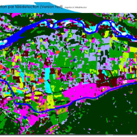
Validation of the results with field data enabled us to calculate an overall accuracy of irrigation mapping in the pilot areas ranging from 60% to 92% for the TETIS method and from 74% to 92% for the CESBIO method, depending on the pilot areas and the year. This experiment enabled the methods to be validated on the selected pilot territories. Mapping was then carried out on the scale of the Durance basin, demonstrating the suitability of the methods for large-scale monitoring.
The results can be viewed on the results display interface on the SMAVD website :
https://cartotheque.smavd.org/index.php/view/map?repository=irrigation&project=Teledetection
These results constitute a reference dataset on crops and irrigation within the framework of the SAGE Durance. They feed the C3PO integrated resource-use modelling tool to refine the estimation of irrigation needs.
=> Consult the study report (October 2022) and its summary (July 2023)